
Strategic Cartography: Geospatial Insights into Building age Dynamics for Sustainable Urban Resilience in Dormaa Ahenkro, Ghana
Keywords:
Urban Resilience, Building Age Dynamics, Sustainable Development, Gis, Geospatial Analysis.Abstract
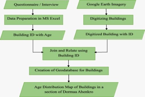
Dormaa Ahenkro town ship has been in existence for many centuries and that, there are different kinds of buildings in the city. With regard to the ages of the buildings which is very important for authorities to track the history of some buildings for safety and economic resources. This study navigates the intersection of geospatial technology and urban development. Leveraging QGIS 3.16 and Google Earth pro, a meticulous analysis of 243 buildings in Dormaa Ahenkro unveils a nuanced understanding of their temporal and functional dynamics. The digitization process reveals 220 old and 23 new structures, forming the foundation for an exploration of the architectural evolution of the city. Temporal insights, spanning from the year 1820 to 2023, illuminate the historical narrative of Dormaa Ahenkro, while an SQL (Structured Query Language) was used to categorize buildings based on their conditions and purposes. Clusters of buildings, as depicted spatially, not only signified temporal patterns but also conveyed functional diversity, with some structures serving dual purposes-commercial and residential. The SQL used to query data from the geodatabase in GIS highlighted the urgency of addressing aging structures, identifying 133 buildings in need of maintenance and emphasizing the historical significance of the oldest building at 193 years. The study recommends targeted preservation initiatives for historical buildings, balanced urban planning strategies, routine maintenance programs, resilient design regulations, and community engagement initiatives. These recommendations provide a strategic framework for Dormaa Ahenkro to preserve its heritage, foster sustainable growth, and fortify resilience against evolving urban challenges. The integration of geospatial insights and strategic cartography emerges as a powerful tool for informed decision-making in shaping a resilient and sustainable urban future for Dormaa Ahenkro, Ghana.
Published
How to Cite
Issue
Section
Copyright (c) 2023 Authors

This work is licensed under a Creative Commons Attribution 4.0 International License.
